top of page
SAM PERERA
FIRST EDITION
COLLECTION
VIEWPOINT MAPS

c1851
Map of Ceylon
John Tallis and John Rapkin
This is an original steel engraving with original and later hand colour. The map is a decorative and detailed mid-19th century map of Ceylon which was drawn and engraved by J. Rapkin (vignettes by H. Warren and J. Smith) and published in John Tallis's Illustrated Atlas (London & New York: John Tallis & co, c. 1851). The original page of descriptive text which accompanied the map is included. The Illustrated Atlas, published from 1849 onwards, was the last decorative world atlas.
The "Ceylon" map was typical of the many fine ones which appeared in this work with its decorative border and attractive vignettes. Decorative Vignettes Lake of Kandy, Adams Peak from the Lake of Colorado, Temple of Buddha Kalany and the Ruins of the Dagora at Toopharamaya
John Tallis is without question one of the most renowned cartographers and publisher of the 19th century. His maps are the last of the lavishly decorated and ornamental maps, considered to be works of art as well as geographically accurate. He was born in Stourbridge in Worcestershire in about 1818 and it is likely that he stayed in the Midlands working as a publisher in Birmingham, until he moved to London in the early 1840's.
.webp)
1719
1719 Chatelain Map of Sir Lanka
Henri Abraham Chatelain
A superbly engraved 1719 Chatelain map of Sri Lanka, presenting to Chatelain's Francophone
audience the distant island during the period after the Dutch wrested control of its trade from the
Portuguese. The map is accompanied by seven boxes of French test describing the island's
history and government, with a particular focus on the current state of affairs:
The Dutch, being masters of the coasts, do not allow any vessels other than theirs to dock on
the island of Ceylon, which means that they are the only ones who are also masters of trade.
Thus, they are the ones who provide cinnamon to the rest of the universe, as well as cloves,
nutmeg and mace which grow in the islands of Bantam, Ternate, and Amboyna.

1574
1574 Munster/Ptolemy Map of Ceylon, Sir Lanka, or Tapobrana
Sebastian Mûnster
This is Sebastian Mûnster's 1574 map of Sumatra - using the Ptolemaic model for the map of
Taprobana, which earlier mapmakers typically conflated with Sri Lanka. The map is oriented to the
north and includes all of 'Taprobana' with a nineteen surrounding island. The mainland of the appears
above and to the right, which would correspond to the Melay peninsula were the map correctly
identified with Sumatra, although this map roughly identifies Sri Lanka's tear shape. To the left of the
map is a naturalistic illustration of an elephant and ten lines of text describing the pepper trade -
explicitly identifying the island as Sumatra. In doing so, Mûnster is differentiating himself from earlier
cartographers whose version of this map reproduced Ptolemy's map by rote - though he adds no new
specific data to the map, his innovation is in the application of a specific modern interpretation of the
ancient geographical data.

1916
Map Land Registry London Sheets IX.2
Director General at the Ordnance Survey Office, Southampton
General at the Ordnanace Survey Office, Southampton 1916. The map covers the area from Vauxhall in the west to Walworth Road in the East, The Oval and Clapham Road in the South to Kennington to the North of the map.
1916
Map Land Registry London Sheets IX.1
Director General at the Ordnance Survey Office, Southampton
The map covers the area from Houses of Parliament in the west to Borough Street in the East, St Jude's Ward in the South to Waterloo and Southwark to the North of the map. The map contains original hand annotations including one stating "in Parliament - Sessions 1948-1949 - Public Works - Festival of Britain" and also another set of hand annotation regarding work to Hungerford Bridge and also the Tramways near Waterloo Station.

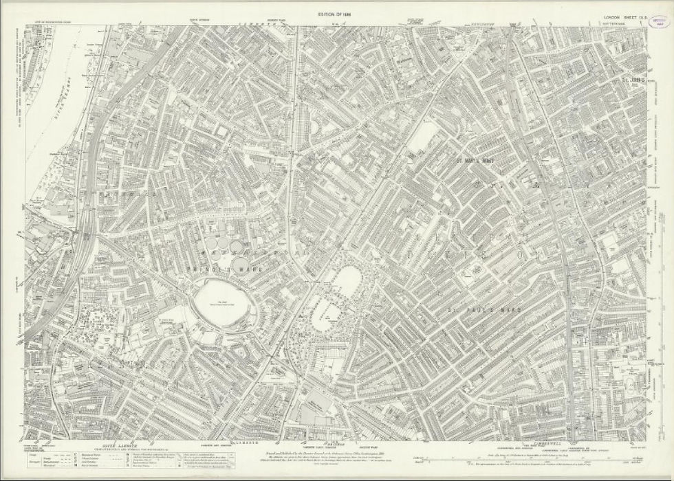
1916
Map Land Registry London Sheets V.14
Director General at the Ordnance Survey Office, Southampton
The map covers the area from Houses of Parliament in the west to Borough Street in the East, St Jude's Ward in the South to Waterloo and Southwark to the North of the map. The map contains original hand annotations including one stating "in Parliament - Sessions 1948-1949 - Public Works - Festival of Britain" and also another set of hand annotation regarding work to Hungerford Bridge and also the Tramways near Waterloo Station.

c1933
Ceylon, Her tea and other Industries (map of Ceylon)
Leslie MacDonald Gill
Macdonald Leslie Gill (1884-1947), or Max he was known to his friends, was a versatile and highly sought-after commercial artist, cartographer and illustrator who produced extraordinary works for Commonwealth Governments, industry bodies and (most notably) London Transport. Whilst his work spread across a broad spectrum of commercial design, it was was his detailed pictorial maps that he was best known. In 1913, Gill produced a highly detailed and engaging map of London for the London Underground, later called the Wonderground Map of London. Its huge popularity lead to a resurgence in pictorial map design both by Gill himself and many others trying to achieve the same intrigue, mainly for marketing purposes. Later in Gill's career, he created various maps for Commonwealth Governments with the 1933 map "Ceylon - Her Tea and Other Industries" being the first of this kind. Similar maps of Australia and New Zealand would follow, produced as propaganda posters during WWII.
This map of Ceylon was originally commission in 1933 by the Ceylon Tea Propaganda Board (CTPB) whose mission was to reverse the decline in tea drinking (particularly in Britain which represented nearly 70% of its market). Over a period of 15 years a few versions of this map have been published as the СТРВ (later named The Tea Bureau and then The Tea Centre) in response to increasing competition from India and other tea exports.

1942
Map of Canada and Newfoundland - Their Natural and Industrial Resources
Leslie MacDonald Gill
Colour lithograph map of Canada. The map is a beautiful and unique pictorial map of Canada by Macdonald Gill in 1942 that was commissioned by the UK's Ministry of Information during World War 2 to showcase the natural and industrial resources of the British Empire. The map focuses on the industrial and natural resources of Canada and her "Atlantic neighbour" Newfoundland, showing how the country has thrown all their material resources into the struggle' of World War 2. The map says that 'Canada's output of of munitions, arms, ships, metal and food, was made possible by tremendous industrial growth' and that the country 'moves forward to a great industrial future.' Excellent Condition - The map has been backed on conservation Japanese paper. The map is wonderfully bright and has no folds. A remarkable survivor.

1869
Wyld’s New Plan of London
James Wyld
A large and appealing hand coloured folding cloth/linen backed pocket map of London, England issued by James Wyld II in 1869. The map is centered on the River Thames and covers central London from Paddington Cemetery in the northwest to Hudson Town in the northeast, and from Parson’s Green in the southwest to Greenwich Park in the southeast.
Made with the foreign tourist in mind, Wyld’s map shows most streets, important buildings, inns, churches, trading centers, markets, parks, and rail lines. The map is surrounded by a decorative border bearing engraved views of famous London attractions, including London Bridge, the Bank of England , the Crystal Palace, the Houses of Parliament, and many others. The map details titles in French and German, to the right and left of the primary title. Respectively, James Wyld II first issued this map in 1851 and it went through multiple states to reflect the rapid urban development of that Victorian period that transformed London into the first truly modern metropolis.

1845
A New Chart of the World On Mercator’s Projection With the Tracks of the Most Celebrated & Recent Navigators
Henry Teesdale & Co
Engraver: John Dower
This fantastic large-scale New Chart of the World on Mercator’s Projection details the most celebrated and recent navigators and is also notable for the Northwest Passage and Texas.
The map is a stunning example of a full, vibrant period hand coloured folding world map. This map is an extremely rare issue with very important updates to 1845. The map is an extraordinary compendium of oceanic exploration and contains voyage tracks from the 15th century to those contemporaneous with the map including those relating to polar and northwest passage related as well as south polar explorations. This is an impressive 1845 large format map of the world by Henry Teesdale. The map covers the entire world on a Mercator projection with copious notes and annotations throughout. The map is thorough, but predictably presented via a highly Anglo-centric perspective - for example the discoveries of John Wilkes and the U.S Exploring Expedition are completely omitted, no doubt in an effort to bolster the competing exploratory claims of Englishman John Russ.
Teesdale’s map is beautifully presented in two sections, each of which have been dissected into sixteen panels and backed on linen for easy folding and unfolding. The enormous size of this map allows Teesdale to accommodate a quantity detailed annotation explaining of natural wonders, historical events, expirations, and political treaties. These are so prolific and charming we will allow them to speak for themselves. Texas is represented at its fullest extent as in independent republic. An annotation reads: Texas was acknowledged as Independent State by England, November 1840.
Just off the coast of Norway, at all site of the legendary Loften Maelstrom, the following annotation reads: The Maelstrom, This celebrated Whirlpool is an immense circle of a mile and a half in diameter; the Velocity increasing as it approximates the center, there forming a vortex, the largest Ship meet with instant destruction on entering it.
Off the northeastern coast of Australia the Great Barrier Reef is recognised in conjunction with the HMS Bounty Mutiny: Great Barrier Reefs, here the Ship Pandora Capt. Edwards with 14 of the Mutinous crew of the Bounty on board who were captured at Otaheite was lost, 35 of the Crew and 4 of the Prisoners perished in the latter end of June 1791.
In Liberia, Africa: This district has been purchased from the Native Chiefs by a Company of American Philanthropists, (called the Colonization Society) for the purpose of forming Settlements for the Emancipated Slaves of the United States, and is now in a flourishing condition. There are just a few of the dozens of interesting annotations throughout.
Henry Teesdale (1776-1855) published maps and atlases, many in collaboration with this map's engraver, John Crane Dower (1791?-1847), a very prolific engraver, draughtsman, publisher and printer. The prominence of Dower's name in the map's title and the absence of a mapmaker listed on the map suggest that Dower's role in its production was more than the engraving of it. Henry Teesdale who published two important maps, also by Dower, relating to Australia in 1831, became a partner in the Royal Bank of Australia in 1845.

c1927
The Wonderground Map of London Town
Leslie MacDonald Gill
Publisher: The Westminster Press (London)
The Wonderground Map of London Town showing the Heart of Britain’s Empire Here is Spread Out for Your View. The Wonderground Map of London Town shows you many stations & bus routes not a few. You Have Not the Time to Admire it all? Why Not Take a Map Home to Pin on your Wall.
The Wonderground Map of London Town - showing The Heart of Britain's Empire Here is Spread Out for Your View. The Wonderground Map of London Town shows you many stations & bus routes not a few.
You Have Not the Time to Admire it all? Why Not Take a Map Home to Pin on your Wall!
The Wonderground Map of London Town is a caricature map of central London, west to Hammersmith, north to Camden Town, east to St Katherine's Dock and south to Clapham, draws its inspiration from Lewis Carroll's 'Alice in Wonderland. It shows London filled with elevations of underground stations and other important buildings, unusual vignettes and esoteric references and puns.
For example: the Serpentine River hosts a Chinese dragon; a man hangs from Tyburn Tree; and next to Regents Park Zoo are three verses of William Blake's 'The Tyger'. An armorial depicting a tunnel, surmounted with a white rabbit, with a Latin motto translating as 'Enter or exit with little delay', strengthens the Wonderland comparison. Leslie MacDonald Gill (1884-1947), younger brother of Eric Gill, specialised in graphic design in the Arts and Crafts style. His most important commission was from the Imperial War Graves Commission, designing the script used on Commission headstones and war memorials, including the Thieval Memorial to the Missing of the Somme'. He originally drew this map as an advertising poster for London Electric Underground Railway Company in 1914. Such was its success that a commercial version was issued the following year, available to the general public. This updated version appears to date from c. 1927, when Greyhound racing started at Wembley Stadium: a greyhound is shown racing along the Harrow Road. Down Street Underground Station is shown, before its closure in 1932.

c1851
British America
John Tallis and John Rapkin
This is an original steel engraving with original and later hand colour. The map is a decorative and detailed mid-19th century map of British America which was drawn and engraved by J. Rapkin published in John Tallis's Illustrated Atlas (London & New York: John Tallis & co, c. 1851). The original page of descriptive text which accompanied the map is included.
The Illustrated Atlas, published from 1849 to 1853, was the last decorative world atlas. The 'British America' map was typical of the many fine ones which appeared in this work with its decorative border and attractive vignettes. Illustrated are views of the City of Boston, Fury and Hecla, 'Esquimaux (Eskimoes), whale fishing, polar bears and a seal engraved by J. Rapkin (vignettes by H. Warren & R. Wallis). An interesting feature of the map is that, at the time of its publication, Alaska was part of Russia i.e., 'Russian America'.
John Tallis is without question one of the most renowned cartographers and publisher of the 19th century. His maps are the last of the lavishly decorated and ornamental maps, considered to be works of art as well as geographically accurate. He was born in Sturbridge in Worcestershire in about 1818 and it is likely that he stayed in the Midlands working as a publisher in Birmingham, until he moved to London in the early 1840's.

1916
Land Registry Map - London Sheet V.13
Edward Stanford of 12, 13, 14 Long Acre, WC.
The map covers the area from Sloane Street in the west to Horse Guards in the East, Victoria Station in the South to Mayfair to the North of the map. The map contains original hand annotations including one stating “London County Council General Powers” and also another set of hand annotation regarding the widening of Curzon Street and also the widening of Horseferry Road.

c1906 - 1909 (Code 12607)
Map of Ceylon
Edward Stanford of 12, 13, 14 Long Acre, WC
The map is a coloured lithograph map of Ceylon dissected and laid down onto cloth folding into the original boards with the original map seller, Sifton, Praed & Co Ltd of 67 St Jame’s Street, S.W.
This map would have been a bespoke issue where the coloured lithograph single sheet map has been dissected and laid down into cloth to create one large map that then folds into the original boards.
The map was printed and published in London, Edward Stanford (Geographer to Her Majesty) 12, 13 & 14 Long Acre, W.C and sold via Sifton, Praed & Co Ltd.

c1851
Map of Arabia
John Tallis and John Rapkin
This is an original steel engraving with original and later hand colour. The map is a decorative world atlas. The ‘Arabia’ map was typical of the many fine ones which appeared in this work with its decorative border and attractive vignettes. Illustrated are views of Mount Sinai, a dromedary camel and Arab men and women.
John Tallis is without question one of the most renowned cartographers and publisher of the 19th century. His maps are the last of the lavishly decorated and ornamental maps, considered to be works of art as well as geographically accurate. He was born in Stourbridge in Worcestershire in about 1818 and it is likely he stayed in the Midlands working as a publisher in Birmingham, until he moved to London in the early 1840’s.


bottom of page